Connectivity

SNN Sarjapur Road Location — Kudlu, Off Haralur Road, Bengaluru 560068

SNN Sarjapur Road occupies roughly 30 acres at Kudlu, off Haralur Road and Silver County Road, immediately behind the completed SNN Raj Etternia development. The site pin is 12.8880056, 77.6649778 — Plus Code VMQ7+6X5, PIN 560068. That pincode matters more than it looks: it is shared by three operational Namma Metro stations, which makes proximity here checkable rather than claimed. Inside the Bengaluru search area, SNN Raj Azaleas helps buyers keep the map conversation grounded in actual routines instead of only distance claims.

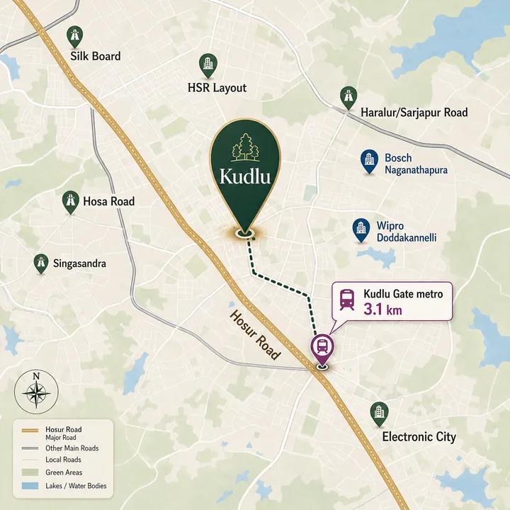
SNN Sarjapur Road Location Map

SNN Sarjapur Road location map showing Kudlu Gate metro at 3.1 km by road, Hosa Road and Singasandra stations, Hosur Road, Haralur and Sarjapur Road, Bosch Naganathapura, Wipro Doddakannelli, HSR Layout, Silk Board and Electronic City

Location Map — SNN Sarjapur Road

Where SNN Sarjapur Road sits in South-East Bengaluru

The address sits inside a triangle whose three sides are the city's three highest-employment road corridors. Hosur Road (NH-44) runs down the western edge toward Electronic City. Sarjapur Road runs north-east toward the Outer Ring Road tech belt. The Outer Ring Road itself closes the triangle at the top, through Bellandur and Marathahalli. Kudlu is the interior of that shape — a village pocket absorbed into BBMP limits in 2007, and now into the Greater Bengaluru Authority's Bengaluru South corporation.

For two decades that interior position was a liability. It meant being close to everything on a map and stuck behind two of the country's worst junctions in practice. Two infrastructure events changed the arithmetic. The Namma Metro Yellow Line opened on 10 August 2025 and put three stations inside a 3–5 km road radius. The Central Silk Board double-decker flyover completed trials on 22 April 2026 and opened fully on 25 April 2026, easing the single choke point every northbound trip from this pocket had to clear.

The site is zoned Hi-Tech under CDP 2015 and approved through BDA. Its immediate frontage is Hosa Lake along the southern boundary, roughly 0.15 km from the pin at nearest water's edge.

SNN Sarjapur Road and Kudlu Gate metro station — the connectivity case

Yellow Line (Line 3), RV Road to Bommasandra. Inaugurated 10 August 2025, public service from 11 August 2025. 19.15 km, 16 stations, fully elevated, depot at Hebbagodi. The ordered sequence is RV Road, Ragigudda, Jayadeva Hospital, BTM Layout, Central Silk Board, Bommanahalli, Hongasandra, Kudlu Gate, Singasandra, Hosa Road, Beratena Agrahara, Electronic City, Infosys Foundation Konappana Agrahara, Huskur Road, Biocon Hebbagodi, Bommasandra.

Three consecutive stations on that list sit within a short drive of the project, and all three carry PIN 560068 — the project's own.

StationStraight-line from siteBy roadDetour factorStatus
Kudlu Gate2.79 km~3.1 km — nearest by road1.12×Operational, staffed, step-free
Hosa Road2.35 km~3.7–5.3 km1.59×Operational, staffed, step-free
Singasandra2.32 km — nearest as the crow flies~4.3–6.4 km — farthest by road2.07×Operational, staffed, step-free

Why the nearest station on a map is not the nearest station in a car

This is the one thing about this location that most published material gets wrong, and it is worth stating plainly.

Measured as the crow flies, Singasandra is the closest station at 2.32 km. Measured on the actual road network, it is the farthest — between 4.3 km and 6.4 km depending on which egress you take. The reason is structural: Hosur Road at this point is an elevated expressway with service roads and a continuous median. You cannot cross it where the straight line wants you to. Every routing engine, on every alternative it generates, puts Singasandra farther by road than Kudlu Gate.

Kudlu Gate is the station residents will actually use. At ~3.1 km by road it is the shortest run from the site, and it is the most reliable figure in the whole set — two independent routing engines agreed on it to within ten metres, and a separate locality source independently gives 3.4 km as the nearest metro to Haralur Road. The route runs out via the site access road to Kudlu Road and onto Hosur Road. Kudlu Gate station has two exits, and Exit 2 serves Kudlu Gate Village and the lake side — the residential approach rather than the industrial one.

Anyone comparing apartments near Kudlu Gate metro station against apartments near Hosa Road or Singasandra should apply the same correction. Straight-line proximity in this pocket systematically overstates access, and the further north-east you go from Hosur Road, the worse the gap gets.

Frequency, interchanges and where the line actually takes you

Frequency has tightened steadily since opening. The line launched on a 25-minute headway; as of 2026 it runs at approximately 7 minutes at peak and 10–12 minutes off-peak, with BMRCL targeting 4–5 minutes once all fifteen three-car trainsets are in service. Daily Yellow Line ridership is around 84,000, on a network that has passed one million.

Only one interchange is live today: RV Road, onto the Green Line. Two more are under construction and should not be treated as usable yet — Jayadeva Hospital (Pink Line) and Central Silk Board (Blue Line). The Pink Line's Jayadeva interchange is the one that materially changes this location's reach, and it is a target rather than a date.

What already works, with no interchange at all, is the southbound employment run. From Kudlu Gate it is four stops to Electronic City station, five to Infosys Foundation Konappana Agrahara, seven to Biocon Hebbagodi. From Hosa Road it is two, three and five respectively. That converts the Electronic City commute from a Hosur Road traffic problem into a rail journey — which is a far more durable asset than any drive-time claim. Companies in the township are reported to be running last-mile shuttles from the two Electronic City stations, and the corridor's rail option has been credited with strengthening return-to-office policies. The same line reaches SNN Electronic City territory in under fifteen minutes of running time.

The last mile — stated honestly

The site is not walkable to any metro station. Kudlu Gate at ~3.1 km is roughly a 40-minute walk; Hosa Road at 3.7–5.3 km is 50 minutes or more. The site itself sits about 830 m back from Haralur Road proper, an 11-minute walk before the onward journey even begins. Published research puts the walking tolerance of metro users at around 20 minutes — this site is beyond that threshold for every station, and no framing changes that. Station car parking is reported as two-wheeler-only, so park-and-ride by car should not be assumed.

The real answer is the feeder network. BMTC and BMRCL launched eight Yellow Line feeder bus routes in March 2026. Two of them are ring services anchored on Hosa Road metro station whose published stop lists include Haralur and Haralur Cross — on the project's own road.

  • Ring route, clockwise: Hosa Road Metro → Central Prison → National Public School → Haralur → Haralur Cross → Agara → Parangipalya → Somasundarapalya → Kudlu Gate → Singasandra → Hosa Road Metro. 6:00 AM to 9:40 PM.
  • Ring route, counter-clockwise: the same loop reversed, 6:15 AM to 9:20 PM.
  • Linear feeder: Hosa Road Metro ↔ Central Prison → Doddamara → Chikkanayakanahalli → Doddakanneli → Carmelaram. 6:00 AM to 9:00 PM.

Peak frequency runs 15–30 minutes depending on route. A single ring service touches all three of the project's nearby stations. Beyond the buses, auto-rickshaws operate along Haralur Road and are available at Kudlu Gate station, shared autos run at roughly ₹10–20 per person, and app-based cabs serve all Yellow Line stations.

Road connectivity from SNN Sarjapur Road

The site plan provides a 30 m approach road into the development, feeding onto Silver County Road, which connects to Haralur Road toward Sai Meadows and HSR Extension. Haralur Road is the spine: it runs between Sarjapur Road at one end and Hosur Road at the other, with Birla Junction as its principal node, and the first 0.8–2 km of almost every journey from this site runs on it.

From there the network opens out. Kudlu Road carries traffic west to Hosur Road and the Kudlu Gate junction. Hosur Road (NH-44) is the primary north-south artery, and above it runs the tolled Electronic City Elevated Expressway — 9.985 km, four lanes, opened 2010, connecting Silk Board Junction directly to Electronic City Junction and bypassing the worst surface congestion. A six-lane extension from Electronic City to Chandapura is reported to be targeting late 2026. Sarjapur Road provides the north-eastern route to the ORR tech belt, and the Outer Ring Road itself is reached at the Bellandur/Sarjapur Road junction.

DestinationBy road from site
Kudlu Gate metro station~3.1 km
Hosa Road metro station3.7–5.3 km
Singasandra metro station4.3–6.4 km
HSR Layout (BDA Complex)5.7–7.1 km
Wipro junction, Doddakannelli (Sarjapur Road)5.2–6.3 km
Central Silk Board junction~6.4 km
Electronic City Phase 16.2–7.8 km
ORR × Sarjapur Road, Bellandur~8.2 km
Koramangala~8.9 km
Marathahalli Bridge~11.9 km
Heelalige railway station14–16 km
MG Road / CBD14.2–16.1 km
KSR Bengaluru City railway station18–19 km
Kempegowda International Airport48–56 km

Heelalige deserves a footnote: it is the planned southern terminal of Corridor 4 of the Bengaluru Suburban Railway. That is a future option on this location, not a current commuter asset.

Traffic around SNN Sarjapur Road — the honest version

No page in this corridor should publish a free-flow routing time as a drive time, and this one will not.

The TomTom Traffic Index 2025 ranks Bengaluru the world's second most congested city, at 74.4% congestion, 36 minutes 09 seconds to cover 10 km, peak speeds of 14.6 km/h in the morning and 13.2 km/h in the evening, and 168 hours lost per driver per year. Electronic City and the Hebbal–Silk Board stretch of the ORR are named as chronic corridors. Morning rush runs 7:30–10:30 AM, evening rush 5:30–9:00 PM, with the worst of it around 6–7 PM.

Two independent benchmarks calibrate what that means in practice. Bengaluru's Global Capability Centre workforce averages 50 minutes to cover roughly 15 km one way. ORR journeys have been described by Prestige Group's chief executive as taking 55–70 minutes to cover 5 km at peak. Against those numbers, the ~3.1 km run to Kudlu Gate is realistically 11–18 minutes rather than the six minutes a routing engine returns, and the ~6.4 km run to Silk Board is 23–26 minutes rather than ten. The airport is a 1 hour 45 minute to 3 hour journey depending on day and season, never the 55-minute free-flow figure.

This is precisely why the metro line matters. It is not a convenience amenity in this micro-market; it is the only part of the transport system whose journey time is stable.

Employment hubs near SNN Sarjapur Road

The structural fact about this location is that it sits between two employment poles rather than beside one. Electronic City lies 4.3–5.7 km straight-line to the south. The ORR/Bellandur belt — Softzone, Infozone, Pritech Park, RMZ Ecospace, Global Technology Park — lies 4.1–4.6 km straight-line to the north. Both fall inside a 5 km straight-line ring, which is unusual, and it means a household with two earners working in different corridors does not have to compromise.

Employment hubStraight-lineBy roadScale, where sourced
Bosch Naganathapura plants2.0–2.2 km3.8–4.0 kmEstablished 1989; Bosch's third Indian plant. Nearest large employer to the site
Wipro corporate HQ, Doddakannelli3.7 km~5.7 kmWipro's flagship Bengaluru campus
HSR Layout startup cluster3.8 km~5.3 kmHome to the Sector 3 "Unicorn Street" cluster
Salarpuria Sattva Softzone / Infozone, Bellandur~4.1 km~6.5 kmORR office campuses
Electronic City Phase 1~4.3 km6.2–7.8 kmSee township note below
Tech Mahindra, Electronic City~4.4 km~7.6 km
Pritech Park SEZ / RMZ Ecospace, Bellandur~4.4 km~9.0 kmLarge ORR SEZ campuses
Electronic City Phase 24.8–5.7 km7.4–9.0 km
Siemens, Electronic City~4.8 km~7.0 km
Infosys Electronic City campus4.4–5.1 km6.9–8.2 kmReported to house over 30,000 employees
RMZ Ecoworld, Devarabeesanahalli~5 km~8.4 km7.5 msf across 16 towers (RMZ)
Wipro Electronic City campus5.5–5.7 km8.0–8.4 kmReported 25-acre campus
Embassy TechVillage, Devarabeesanahalli~5.5 km~9.8 km84.05 acres, 9.7 msf, 48 occupiers, ~60,000 park users (Embassy REIT)
Cessna Business Park, Kadubeesanahalli~6.1 km~10.8 kmReported ~4.5 msf
Biocon Hebbagodi campus~6.4 km~9.9 km
Koramangala~6.9 km~8.9 kmFintech and funded-startup cluster
Prestige Tech Park, Kadubeesanahalli~6.8 km~10.7 kmFour phases; occupiers include Adobe and Deloitte
Bommasandra Industrial Area (KIADB)~8.9 km~11.2 kmPharmaceuticals, engineering, auto components, electronics

On Electronic City's workforce, the honest position is a range, not a number. ELCITA — the statutory industrial township authority constituted in 2013, Karnataka's first — administers 903 acres 11 guntas across Phases 1 and 2, and is cited at 158 member companies and a township population impact approaching two lakh people. Wikipedia instead gives around 200 IT/ITES campuses and an estimated 100,000 employees across 800 acres. The two are not measuring the same thing and neither is audited. What is settled is the occupier roster: Infosys, Wipro, Tech Mahindra, Siemens, Hewlett Packard, TCS, HCL Technologies, Titan, Bosch and Biocon all maintain campuses inside the measured radius.

On the ORR side, the corridor association describes a 17 km stretch from K.R. Puram to Silk Board carrying 60 million sq ft of office space today, projected toward 100 million, and accounting for 41% of Bengaluru's overall office absorption.

Schools near SNN Sarjapur Road

All distances below are straight-line from the site pin. Road distances in this corridor typically run 1.3–1.8× these figures.

SchoolStraight-line
The Cambridge International School0.40 km
Shree Vidyanikethan1.17 km
Amatra Academy1.23 km
Orchids The International School1.33 km
Vibgyor High1.52 km
Oxford School, Beratena Agrahara1.63 km
Notre Dame Academy1.65 km
Amrita International Vidyalayam2.12 km
Glentree Academy2.41 km
New Baldwin International2.51 km
Sri Chaitanya Techno School3.29 km
Primus Public School3.45 km
NPS East, Sarjapur3.47 km
National Public School, HSR3.96 km
Harvest International4.90 km
DPS Electronic City5.99 km

Sixteen named schools inside 6 km, with a CBSE/ICSE/IB spread and four international-curriculum options inside 1.6 km, is a mature schooling catchment by South-East Bengaluru standards.

Hospitals near SNN Sarjapur Road

Straight-line, same basis as above.

HospitalStraight-line
Raksha Hospital1.57 km
Hospitec1.76 km
Blossom Hospital2.03 km
Apollo Cradle2.36 km
PESU Institute of Medical Sciences2.81 km
Stanford Speciality2.89 km
Narayana Multispeciality3.23 km
Cloudnine3.27 km
Motherhood Hospital3.42 km
Manipal Hospitals3.55 km
Rainbow Children's Hospital3.59 km
Kauvery Hospital3.67 km
Apollo Hospital4.45 km
Sakra World Hospital5.39 km
St. John's Medical College6.90 km
Fortis Bannerghatta7.24 km
Jayadeva Institute of Cardiovascular Sciences7.89 km

Four multispecialty hospitals inside 3.6 km, two maternity and two paediatric specialists inside 3.6 km, and tertiary cardiac care at Jayadeva within 8 km. For a household with dependants, this is the strongest single category in the inventory.

Retail and daily needs around SNN Sarjapur Road

Two things are true at once here, and buyers deserve both.

The immediate Kudlu village pocket genuinely feels thin. Resident feedback aggregated for Kudlu describes limited retail and dining options and points to HSR Layout for malls and supermarkets. That perception is fair for the few hundred metres either side of the site.

The corridor around it is not thin at all. Within 1.2 km of the pin sit a mall, a hypermarket and a multiplex — PNR Felicity Mall on Haralur Road at ~1.16 km, combining a Reliance Smart Superstore, Reliance Digital, a food court and Cinephile, a four-screen laser multiplex on the second floor. It is a convenience mall rather than a destination mall, with reported criticism of parking charges and limited food and entertainment options, and should be read as such.

Grocery depth is the real strength. An OpenStreetMap extraction returns 55 supermarket, convenience and greengrocer points within 3.5 km. The nearest named stores, all straight-line: Loyal World Retail Mart 0.94 km, Safa Supermarket 1.01 km, Reliance Smart Superstore 1.18 km, Freshco Hyperbazaar 1.19 km, Reliance Fresh 1.71 km, Vishal Mega Mart 1.91 km, More 2.20 km, Nilgiri's 2.25 km, FAB Hypermarket 2.46 km, Metro Cash & Carry (wholesale) 2.92 km, MK Retail and Organic World 3.03 km. Larger-format stores including Reliance Smart Bazaar at Bellandur (4.38 km) and DMart outlets at Kasavanahalli, Devarachikkanahalli and Electronic City (4.67–5.11 km) sit within a short drive.

A correction worth publishing: there is no mall at Kudlu Gate junction. Kudlu Gate is the intersection of Hosur Road with Begur Road and Harlur Road — a transit and service-road junction, not a retail destination. Retail there is neighbourhood-grade (Day To Day, Family Food Choice, Food Paradise, Falkon Hypermarket), and the nearest cinema on that side is Narasimha Chitramandira, a standalone hall at 2.77 km. There is likewise no "Market Square Mall Kudlu Gate": the two Market Square Malls in this region are at Madiwala (6.13 km) and Ambalipura, the latter reported as trading on the ground floor only pending renovation.

The genuine big-box malls are all a weekend trip: Market Square Madiwala 6.13 km, Nexus Vega City 7.26 km, Royal Meenakshi 7.62 km, Gopalan Innovation 7.68 km, and Nexus Koramangala 7.79 km — all straight-line, and all materially longer by road across the Hosur Road and Bannerghatta Road grain. Closer alternatives most locality pages miss are the Bellandur retail complex at 4.40 km and M5 ECity Mall with PVR INOX at 5.28 km.

Hospitality is well covered — 51 hotel and guest-house points within 6 km, including Keys Select by Lemon Tree on Hosur Road at 2.18 km, Octave Hotel 3.31 km, DoubleTree Suites by Hilton on Sarjapur Road 3.47 km, ibis Bengaluru Hosur Road 3.84 km, The Oterra at Electronic City 4.23 km, and Fairfield and Courtyard by Marriott on the Bellandur ORR at 4.83 and 4.86 km. For a project whose buyer base includes relocating professionals and NRI families, having four branded business hotels inside 5 km is a practical point, not a decorative one.

Hosa Lake — the southern boundary

The strongest physical feature of this location is not a road. Hosa Lake runs along the entire southern edge of the site, roughly 0.15 km from the pin. The waterbody carries three names in the record — Hosakere in OpenStreetMap, Kudlu Doddakere in Deccan Herald's reporting, and Kudlu Lake in SNN's own earlier marketing — and two sizes, 32 acres and 45 acres, with no single authority among them.

What that boundary delivers is straightforward. A lake edge is an open horizon that cannot be built out: nothing can rise on the southern side to close the view, which is a permanent advantage no internal amenity can replicate. The orientation works in this project's favour too — southern water frontage means the long axis of the view is also the axis that carries breeze across open water rather than across built mass.

The lake carries a walking track, described in route guides at approximately 2 km and by aggregators at 2.5 km. That is a genuine daily-use asset in a corridor where organised open space is scarce, and it functions as the neighbourhood's running and walking loop. Lakes in this belt draw resident and migratory birdlife, and an established waterbody with a mature tree fringe is where that concentrates.

The project's own plan reinforces the edge rather than crowding it. The Revised ToR sets landscape at 49,829.28 sq m — 40.9% of the development area — against ground coverage of just 13.19%, with a further 10.00% held as park and open space and 2,300 trees proposed across twelve species including Kadamba, Neem, Gulmohur, Jacaranda, Nagalinga Pushpa, Arjun and Jamun. A lake buffer is carried in the documentation at 24 m in the ToR narrative and 30 m on the site-plan drawing, alongside a nala buffer of 10 m and 15 m respectively; those two readings remain unreconciled and will settle at approval.

Four more waterbodies sit within easy reach: Haralur Lake 0.76 km, Parappana Agrahara Lake 0.95 km, Kasavanahalli Lake 1.60 km and Singasandra Lake 2.14 km, all straight-line. Kudlu Lake Park, Agara Lake Park and Kaikondrahalli Lake Park are the established recreation circuit for this pocket.

Lake-facing inventory in Bengaluru consistently commands a premium over identical internal stock in the same tower, and in a 30-acre layout with a full southern water edge, a meaningful share of the units can be oriented to claim it.

Honest trade-offs at this location

Traffic is the real cost of living here. Nothing in the metro story fixes the road network. A resident who drives to the ORR at peak should budget the 55–70 minutes for 5 km that industry itself quotes, not a routing estimate. The metro is the mitigation, and it only works for trips the Yellow Line actually serves.

The immediate surroundings are pre-launch, not built out. Fresh Terms of Reference are under examination, there is no RERA registration yet, and indicative launch and completion are Q1 2027 and Q1 2032 — both marked tentative in the project documentation. A buyer at this stage is underwriting the corridor and the plan, not walking a finished neighbourhood.

No station is walkable, and no amount of framing changes that. At ~3.1 km to Kudlu Gate, every metro trip begins with a feeder bus, an auto, a two-wheeler or a car. The March 2026 feeder routes stopping at Haralur and Haralur Cross are the answer, but they are a bus service with 15–30 minute headways, not a five-minute walk.

Road distances here run materially longer than straight-line, and unevenly so. The expressway median is the cause. Singasandra is 2.07× its straight-line distance by road; the ORR at Bellandur looks about 4.1 km away on a map and is 8.2 km to drive — roughly a 2× detour, the largest in the set. Any locality page quoting straight-line figures for this pocket is overstating access by up to double, which is why every table above is labelled.

Haralur Road, the access spine, has been a live civic issue. Emergency asphalting between Birla Junction and Prestige Ferns Residency was carried out overnight in June 2026 on the direction of the Greater Bengaluru Authority Chief Commissioner and the Bengaluru South City Corporation Commissioner, with two further asphalt layers indicated to follow after drainage work. That cuts both ways: the road was poor for months, and the remediation is explicitly a first layer. Drainage, waterlogging and footpath continuity remain open.

The investment case for the Kudlu Gate micro-market

There is no developer price for this project, and none is presented here. What follows is market context from named comparables.

LocalityRate, Jul–Sep 20265-year changeSample depth
Hosa Road₹12,050/sqft+131.7%705 properties, 262 reviews — the deepest and smoothest series in the belt
Kudlu₹12,000/sqft+122.2%~70–75 properties; volatile
Kudlu Gate₹16,000/sqft+196.3%120 properties; the premium pocket
Haralur Road₹15,900/sqft (Apr–Jun 2026)Prior quarter used; the current headline is a data break
Parappana Agrahara₹11,300/sqft−2.6% YoYThe one adjacent pocket that has not appreciated

The gradient is the argument. This site sits physically between the ₹12,000 band at Kudlu and Hosa Road and the ₹15,900–16,000 band at Haralur Road and Kudlu Gate, with the premium pocket's price justified almost entirely by metro adjacency — Purva Kudlu Gate is transacting at ₹16,000/sqft at EOI stage on a 1.7-acre plot 110 m (straight-line) from the station, and Purva Westend averaged ₹15,300–15,350/sqft in Q1 2026. The nearest comparable at scale, Prestige Southern Star, launched at ₹12,000–14,000/sqft across 34–35 acres and 2,130 units. Buyers weighing this belt should also read the Kudlu Gate tower stock directly, where Purva Heritage sets the current benchmark.

Rental yields in this catchment are quoted at 4–6% for Kudlu and 4.5–5.0% for Kudlu Gate. Neither is derived from paired rent-and-price data, so treat them as an indicative band rather than a measurement — though the underlying demand driver is not in doubt, with two employment poles inside a 5 km ring and a rail line running directly into the larger of them.

The structural read is this: at roughly 30 acres and 2,000-plus units, SNN Sarjapur Road is a large-format asset in a micro-market whose branded competing supply is otherwise small — a 1.7-acre single tower and a 2-acre boutique project at Kudlu Gate itself. Scale, a permanent southern lake edge, and three operational metro stations inside a 3–5 km road radius is a combination the immediate belt does not currently offer at any price.

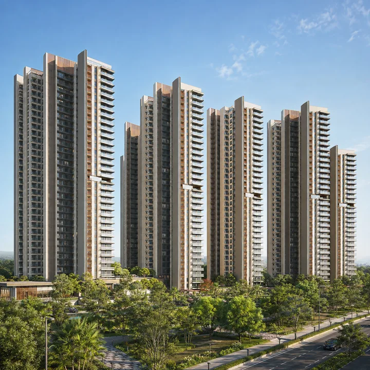
SNN Sarjapur Road residential towers rising 2B+G+24 to 79.95 m above landscaped open space at Kudlu, off Sarjapur Road, Bengaluru

Enquire about SNN Sarjapur Road

Request the brochure, the current cost sheet, floor plates and a site visit for SNN Sarjapur Road.

Enquire Now

SNN Sarjapur Road Location - Frequently Asked Questions

By metro it is three stops from Singasandra — Hosa Road, Beratena Agrahara, then Electronic City — with Infosys Foundation Konappana Agrahara and Biocon Hebbagodi further down the same line. By road the tolled Electronic City Elevated Expressway, 9.985 km and open since 2010, bypasses the worst of the Hosur Road surface traffic. Electronic City is a commute destination from this address, not its location, and the distinction matters when you compare listings. Buyers weighing an address inside the tech belt itself can compare SNN Electronic City for the same developer's product in that market.

Honestly, bad — and that is the strongest argument for buying near a metro station here. TomTom's 2025 Traffic Index ranks Bengaluru the world's second most congested city at 74.4% congestion, with an average of 36 minutes 9 seconds to cover 10 km, peak speeds of 14.6 km/h in the morning and 13.2 km/h in the evening, and 168 hours lost per driver per year. Electronic City and the Hebbal–Silk Board Outer Ring Road stretch are both named chronic corridors. Two things offset it locally: the Silk Board double-decker flyover opened fully on 25 April 2026, and the Electronic City elevated road takes the through traffic off Hosur Road. The larger offset is the Yellow Line itself, now running at roughly seven-minute headway at peak and 10–12 minutes off-peak, carrying about 84,000 riders a day, with BMRCL targeting four to five minutes once all fifteen trainsets are in service.

Straight-line from the pin, the nearest private schools are The Cambridge International School at about 0.40 km, Shree Vidyanikethan at 1.17 km, Amatra Academy at 1.23 km, Orchids The International School at 1.33 km and Vibgyor at 1.52 km, with NPS East Sarjapur at about 3.47 km. On healthcare, Raksha is at roughly 1.57 km, Apollo Cradle at 2.36 km, Narayana Multispeciality at 3.23 km, Manipal at 3.55 km and Sakra World at 5.39 km, with Fortis Bannerghatta and Jayadeva Cardiology at the 7–8 km mark. Every one of those is geometric distance, so add a realistic road multiplier before you plan a school run.

Kudlu Gate is the station you will actually use — about 3.1 km by road, the shortest drive of the three. The straight-line ranking is misleading here and worth understanding: as the crow flies Singasandra is closest at 2.32 km, then Hosa Road at 2.35 km, then Kudlu Gate at 2.79 km, but the Hosur Road elevated-expressway and its service-road median force a long detour, so by road that order reverses and Singasandra becomes the farthest at roughly 4.3 to 6.4 km. Straight-line distance is not road distance — the site sits behind Etternia on a lane network, so actual driving distance is materially longer. All three are on the Namma Metro Yellow Line, the 19.15 km RV Road to Bommasandra corridor inaugurated on 10 August 2025 with 16 fully elevated stations, and all three share the project's own 560068 pincode, which is a checkable proximity proof. The site is not walkable to any of them at roughly 40 minutes on foot, but BMTC introduced eight Yellow Line feeder routes in March 2026, two of which stop at Haralur and Haralur Cross on the project's own road. One caveat before buying on the metro story: RV Road (Green Line) is the only live interchange today — Jayadeva Hospital for the Pink Line and Central Silk Board for the Blue Line are still under construction and should not be treated as usable.

There is no developer price. The project is unlaunched and unregistered, and the pricing sheet circulating with the source documents is a blank template — it carries plot and villa rows, "unlock offer" in every price cell and a payment ladder running to a 45th-floor slab on a 24-storey tower. What can be stated is market context: in the July–September 2026 quarter Hosa Road averaged ₹12,050/sqft, Kudlu ₹12,000/sqft and Kudlu Gate ₹16,000/sqft, with Haralur Road at ₹15,900/sqft in the preceding quarter. The nearest branded comparisons are small-format and priced accordingly — Purva Heritage , a 1.7-acre single-tower pre-launch of around 145 units roughly 110 m (straight-line) from Kudlu Gate metro, is quoting near ₹16,000/sqft at EOI stage, while Mahindra Zen at Singasandra sells 3 BHK at ₹1.99 crore for 1,827 sqft, about ₹10,890/sqft. Scale usually prices below boutique, which is the pocket this project would occupy. A large-format launch here would reasonably sit in the ₹11,500–13,500/sqft band with a working core of ₹12,000–13,000, set against Prestige Southern Star's ₹12,000–14,000/sqft at launch — but that is a market-derived expectation, not a quoted rate.

No. The relationship is purely locational — this land sits behind Etternia in the same village, and that is the whole of it. Etternia is a completed project with its own K-RERA registration under SNN Properties LLP; this is a separate land parcel that will carry its own approvals, its own environmental clearance and its own future RERA number. Some paperwork circulating on this site labels it as a later phase of the neighbouring project, and that label is factually wrong. Nothing about Etternia's sanction, plan or registration extends to this site.